Colombia is a diverse country with distinct geographical regions, political...
Explore Colombia: Maps, Regions, and Ethnic Groups for Kids!
Juliette Natalia Figueroa Palencia@natis_fipal


1 / 14
1
of 14
2
of 14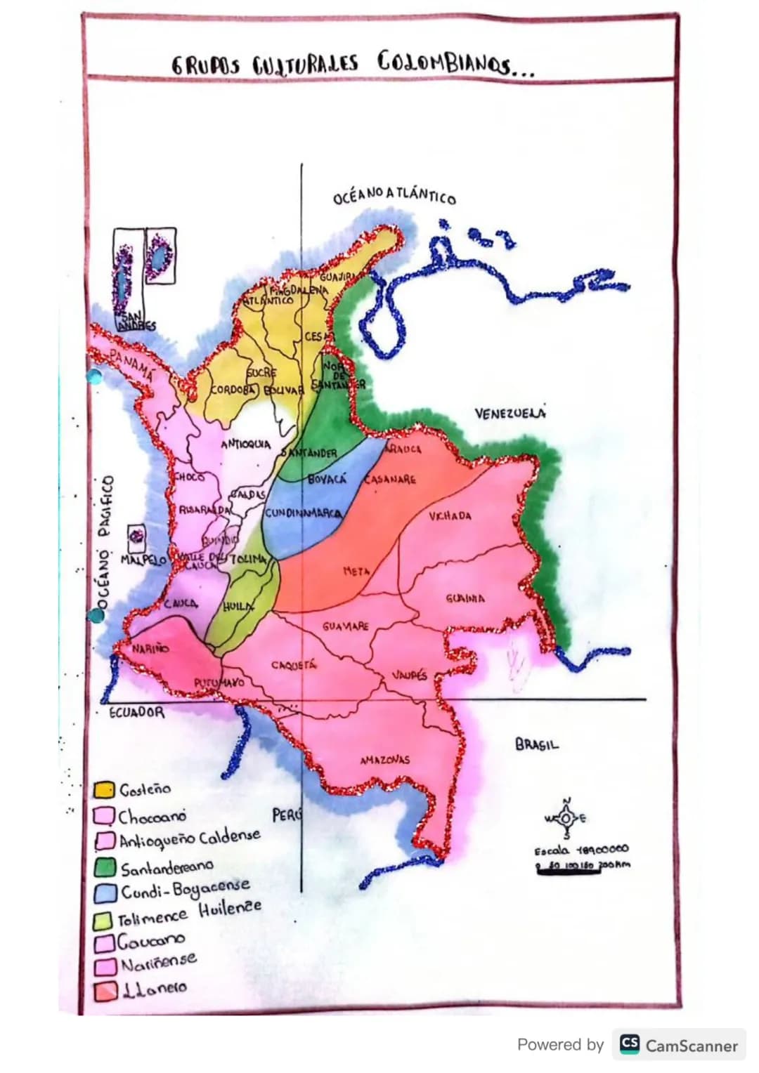
3
of 14
4
of 14
5
of 14
6
of 14
7
of 14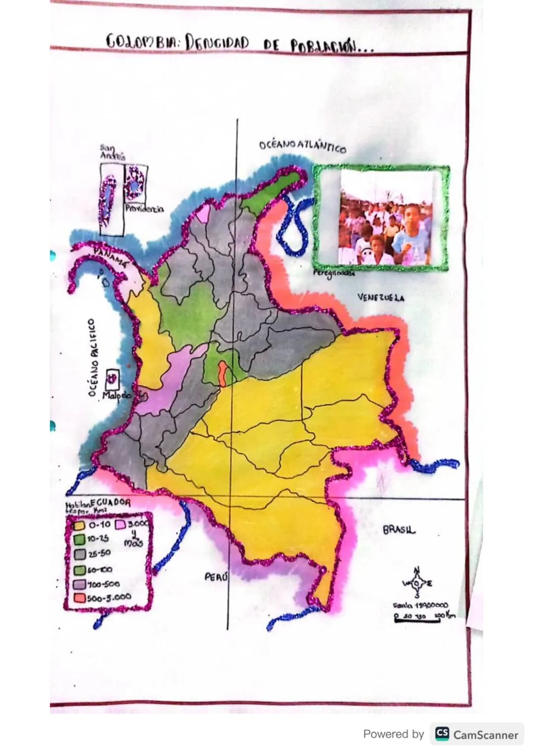
8
of 14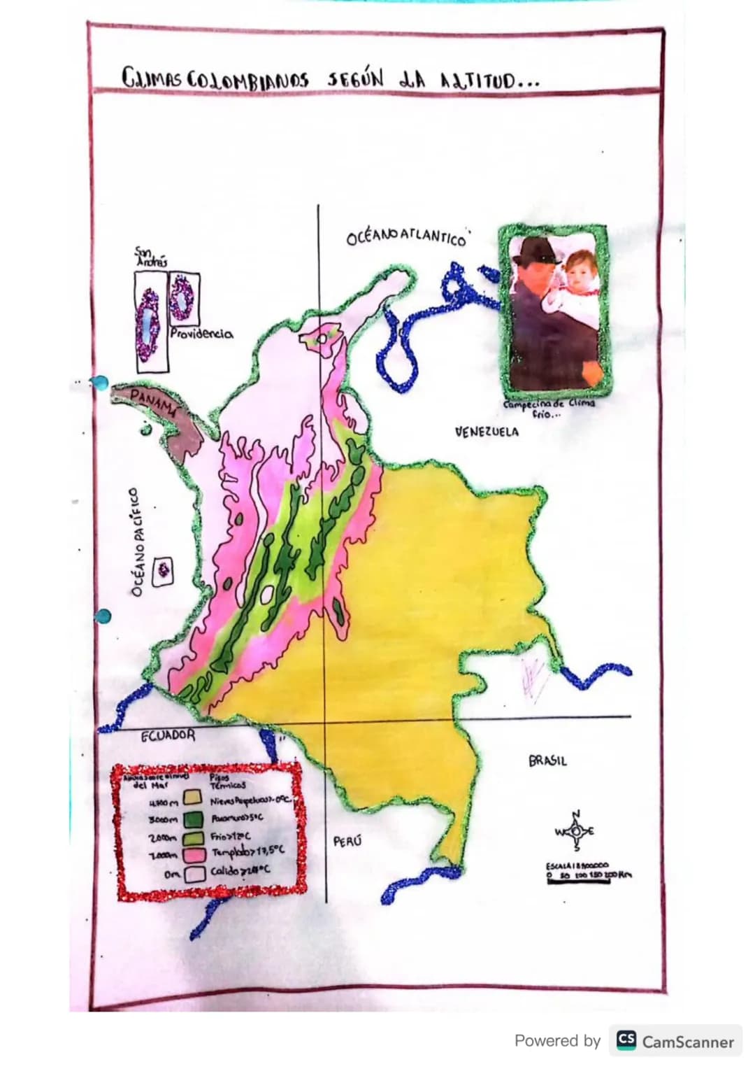
9
of 14
10
of 14
11
of 14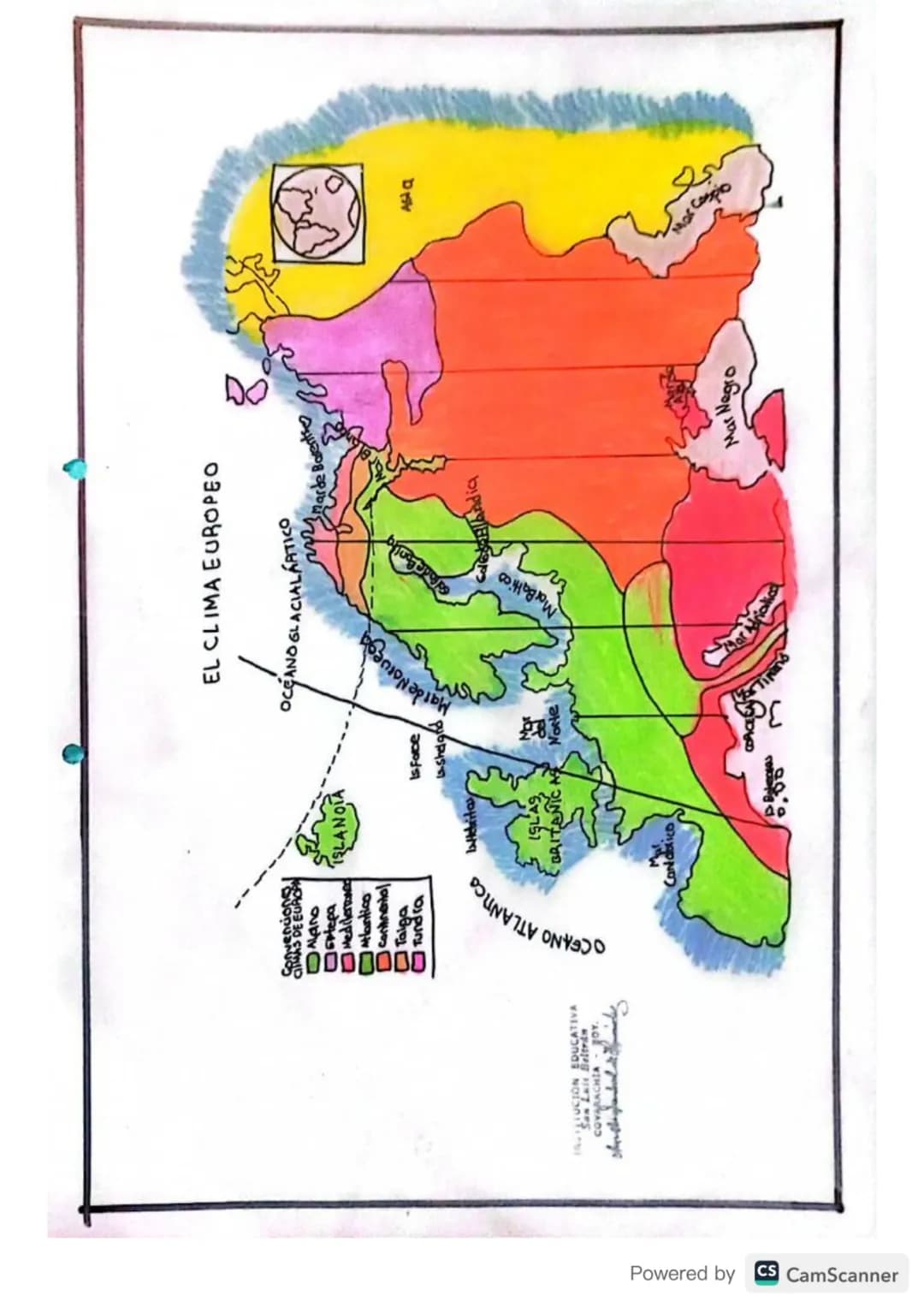
12
of 14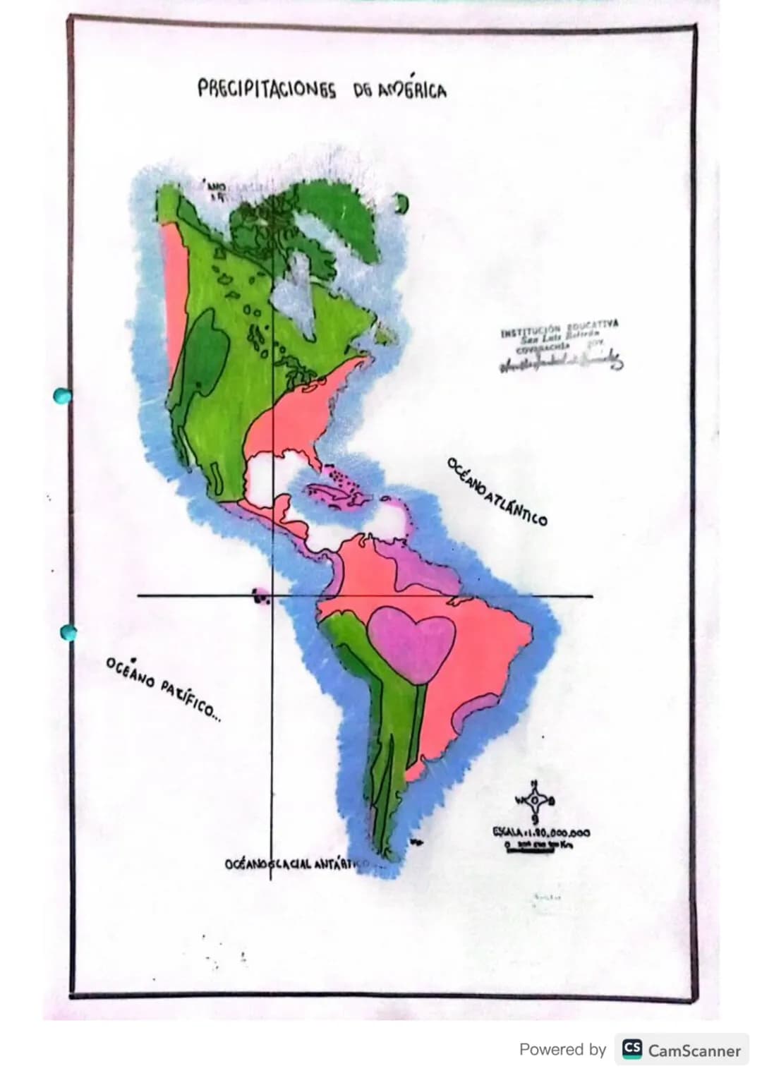
13
of 14
14
of 14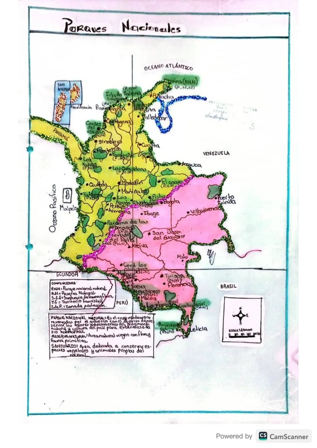
Pensamos que nunca lo preguntarías...
Nuestro compañero de IA está específicamente adaptado a las necesidades de los estudiantes. Basándonos en los millones de contenidos que tenemos en la plataforma, podemos dar a los estudiantes respuestas realmente significativas y relevantes. Pero no se trata solo de respuestas, el compañero también guía a los estudiantes a través de sus retos de aprendizaje diarios, con planes de aprendizaje personalizados, cuestionarios o contenidos en el chat y una personalización del 100% basada en las habilidades y el desarrollo de los estudiantes.
Puedes descargar la app en Google Play Store y Apple App Store.
¡Sí lo es! Tienes acceso totalmente gratuito a todo el contenido de la app, puedes chatear con otros alumnos y recibir ayuda inmeditamente. Puedes ganar dinero utilizando la aplicación, que te permitirá acceder a determinadas funciones.
Contenido similar
Contenidos más populares de Geografía
9Sistema Solar
Planetas en orden
620017
medio ambiente
nos dice como esta constituido el medio ambiente
72865
Geografía urbana:
Desarrollo de las ciudades, problemas urbanos.
93692
Historia de la humanidad
Historia de la humanidad, prehistoria, edad de piedra, bronce, metal, historia, edad antigua, media, moderna y contemporánea.
65497
Geografía colombiana 🇨🇴🗺️
En este formato podremos explorar la geografía colombiana de manera breve y rápida.
81352
Océanos y Continentes
Preparación de miniclase en prácticas como futuro docente
63457
Agentes económicos
3 agentes
9660
idea de collage creativa
es como un armario cuando lo abres esta el collage y a los lados una breve descripción de lo que representa
71664
La primera guerra mundial ( mapa conceptual)
1. cómo comenzó 2.Cuáles eran los nombres de los bandos y países involucrados -Banda triple entente -Banda potencia centrales 3.Dónde se liberó la guerra 4.Cuándo y Por qué terminó 5.Causas 6.consecuencias
82575
Contenidos más populares
9Simulacro ICFES primera sesión calendario B filtrado 2025
Este simulacro te ayudará a sacar un buen puntaje en las pruebas ICFES este 2025. Vamos por ese 500/500. Y poder ser admitido en la universidad que quieras, estudiar la carrera que quieres y no la que te toque. Vamos con toda para sacar un buen puntaje.
1017,321177
Simulacro icfes
Simulacro
112,19352
Cuadernillo Preguntaa Saber 11 Inglés.
Aprovecha los cuadernillos de Inglés para practicar y mejorar tus habilidades en el ítem de Inglés de la Prueba Saber 11. 🫡
Universidad89914
Material de estudio ICFES
Material de estudio, preguntas icfes de matemáticas resueltas
117,149113
Trucos para ganar icfes
Lo mejor
111,07213
ICFES segunda sesión calendario B 2025
Segunda sesión simulacro ICFES 2025 calendario B filtrado, aprovecha y se el mejor ICFES de tu colegio y poder ingresar a universidad, y estudiar aquella carrera con la que tanto sueñas.
119,880124
SIMULACRO ICFES
Simulacro icfes
111,09116
Prueba icfes 2024
Prueba icfes para practicar todas las asignaturas
118468
Matemáticas icfes
Icfes matemáticas
111,82518
Mira lo que dicen nuestros usuarios. Les encantó — y a ti también te encantará.
4.6/5App Store
4.7/5Google Play
La app es muy fácil de usar y está muy bien diseñada. Hasta ahora he encontrado todo lo que estaba buscando y he podido aprender mucho de las presentaciones. Definitivamente utilizaré la aplicación para un examen de clase. Y, por supuesto, también me sirve mucho de inspiración.
Pablousuario de iOS
Esta app es realmente genial. Hay tantos apuntes de clase y ayuda [...]. Tengo problemas con matemáticas, por ejemplo, y la aplicación tiene muchas opciones de ayuda. Gracias a Knowunity, he mejorado en mates. Se la recomiendo a todo el mundo.
Elenausuaria de Android
Vaya, estoy realmente sorprendida. Acabo de probar la app porque la he visto anunciada muchas veces y me he quedado absolutamente alucinada. Esta app es LA AYUDA que quieres para el insti y, sobre todo, ofrece muchísimas cosas, como ejercicios y hojas informativas, que a mí personalmente me han sido MUY útiles.
Anausuaria de iOS
Explore Colombia: Maps, Regions, and Ethnic Groups for Kids!
Juliette Natalia Figueroa Palencia@natis_fipal
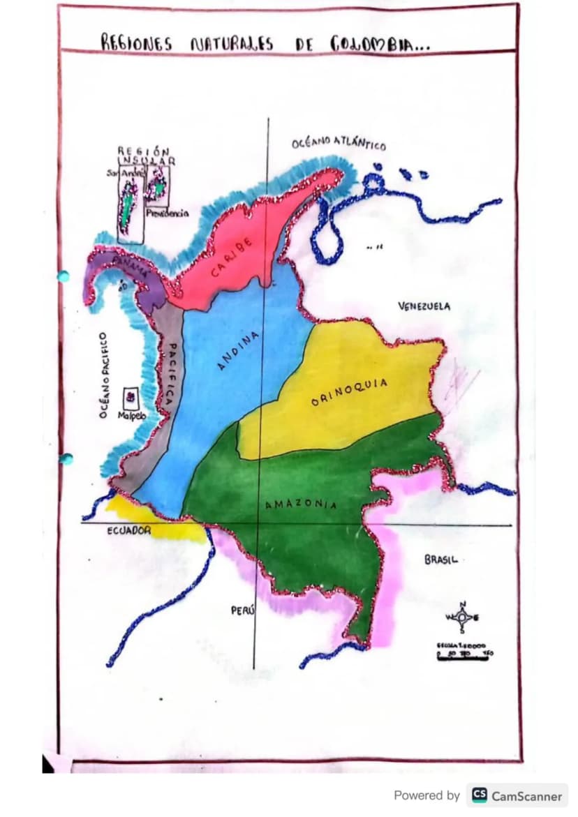
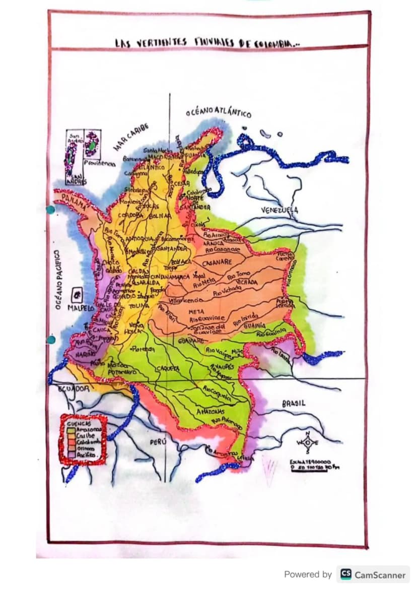
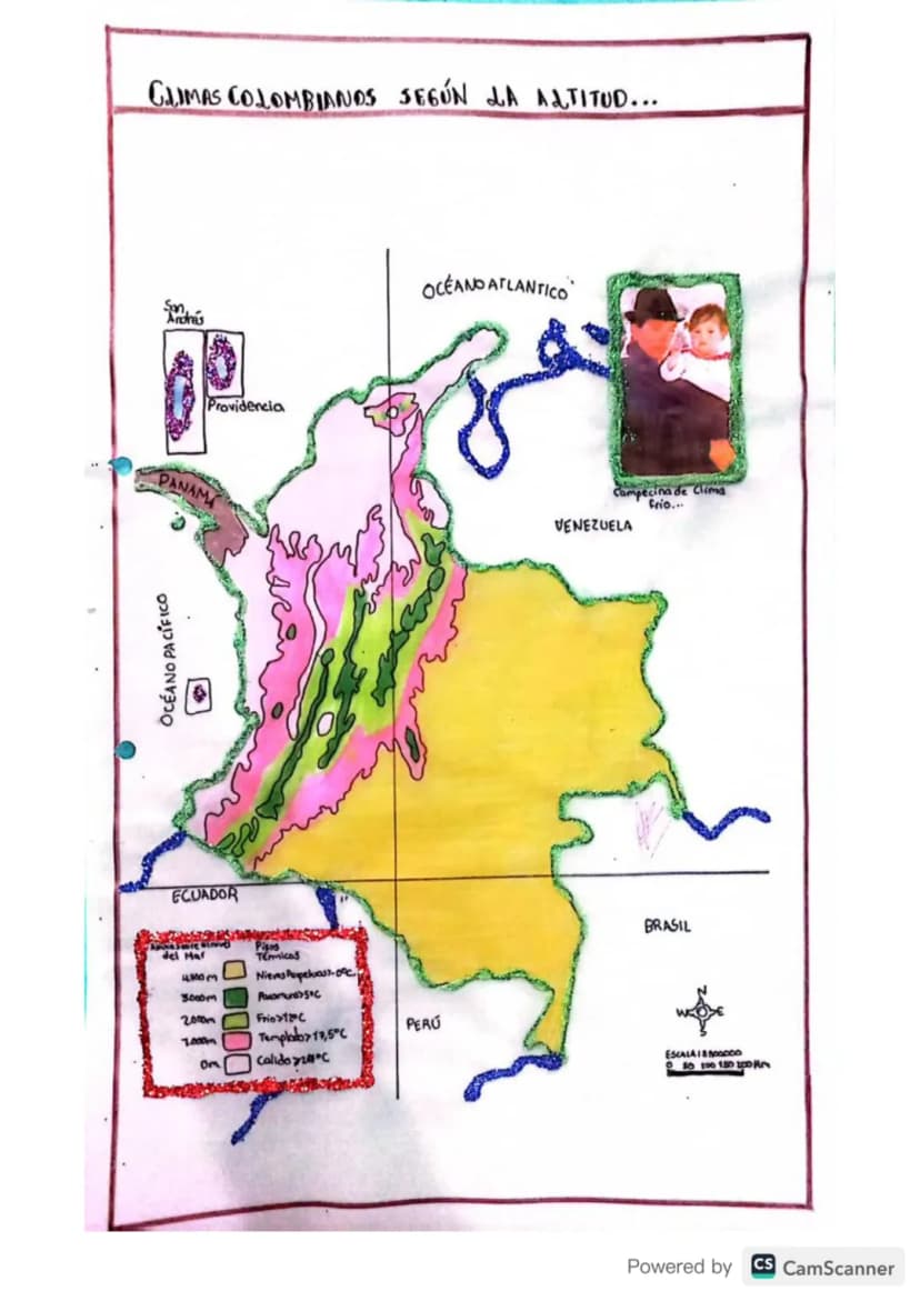
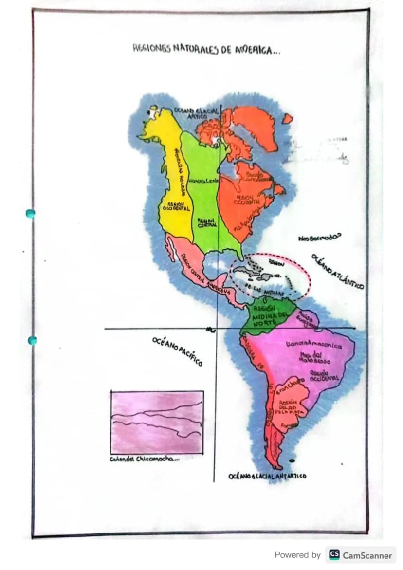
Colombia is a diverse country with distinct geographical regions, political divisions, and rich cultural heritage reflected through its ethnic groups and natural landscapes.
The Mapa Geográfico de Colombiashowcases six major natural regions: the Caribbean, Pacific, Andean, Orinoco, Amazon, and...
1
of 14
Inscríbete para ver los apuntes. ¡Es gratis!
- Acceso a todos los documentos
- Mejora tus notas
- Únete a millones de estudiantes
Al registrarte aceptas las Condiciones del servicio y la Política de privacidad.
2
of 14Inscríbete para ver los apuntes. ¡Es gratis!
- Acceso a todos los documentos
- Mejora tus notas
- Únete a millones de estudiantes
Al registrarte aceptas las Condiciones del servicio y la Política de privacidad.
3
of 14Inscríbete para ver los apuntes. ¡Es gratis!
- Acceso a todos los documentos
- Mejora tus notas
- Únete a millones de estudiantes
Al registrarte aceptas las Condiciones del servicio y la Política de privacidad.
4
of 14Inscríbete para ver los apuntes. ¡Es gratis!
- Acceso a todos los documentos
- Mejora tus notas
- Únete a millones de estudiantes
Al registrarte aceptas las Condiciones del servicio y la Política de privacidad.
5
of 14Inscríbete para ver los apuntes. ¡Es gratis!
- Acceso a todos los documentos
- Mejora tus notas
- Únete a millones de estudiantes
Al registrarte aceptas las Condiciones del servicio y la Política de privacidad.
6
of 14Inscríbete para ver los apuntes. ¡Es gratis!
- Acceso a todos los documentos
- Mejora tus notas
- Únete a millones de estudiantes
Al registrarte aceptas las Condiciones del servicio y la Política de privacidad.
7
of 14Inscríbete para ver los apuntes. ¡Es gratis!
- Acceso a todos los documentos
- Mejora tus notas
- Únete a millones de estudiantes
Al registrarte aceptas las Condiciones del servicio y la Política de privacidad.
8
of 14Inscríbete para ver los apuntes. ¡Es gratis!
- Acceso a todos los documentos
- Mejora tus notas
- Únete a millones de estudiantes
Al registrarte aceptas las Condiciones del servicio y la Política de privacidad.
9
of 14Inscríbete para ver los apuntes. ¡Es gratis!
- Acceso a todos los documentos
- Mejora tus notas
- Únete a millones de estudiantes
Al registrarte aceptas las Condiciones del servicio y la Política de privacidad.
10
of 14Inscríbete para ver los apuntes. ¡Es gratis!
- Acceso a todos los documentos
- Mejora tus notas
- Únete a millones de estudiantes
Al registrarte aceptas las Condiciones del servicio y la Política de privacidad.
11
of 14Inscríbete para ver los apuntes. ¡Es gratis!
- Acceso a todos los documentos
- Mejora tus notas
- Únete a millones de estudiantes
Al registrarte aceptas las Condiciones del servicio y la Política de privacidad.
12
of 14Inscríbete para ver los apuntes. ¡Es gratis!
- Acceso a todos los documentos
- Mejora tus notas
- Únete a millones de estudiantes
Al registrarte aceptas las Condiciones del servicio y la Política de privacidad.
13
of 14Inscríbete para ver los apuntes. ¡Es gratis!
- Acceso a todos los documentos
- Mejora tus notas
- Únete a millones de estudiantes
Al registrarte aceptas las Condiciones del servicio y la Política de privacidad.
14
of 14Inscríbete para ver los apuntes. ¡Es gratis!
- Acceso a todos los documentos
- Mejora tus notas
- Únete a millones de estudiantes
Al registrarte aceptas las Condiciones del servicio y la Política de privacidad.
Pensamos que nunca lo preguntarías...
Nuestro compañero de IA está específicamente adaptado a las necesidades de los estudiantes. Basándonos en los millones de contenidos que tenemos en la plataforma, podemos dar a los estudiantes respuestas realmente significativas y relevantes. Pero no se trata solo de respuestas, el compañero también guía a los estudiantes a través de sus retos de aprendizaje diarios, con planes de aprendizaje personalizados, cuestionarios o contenidos en el chat y una personalización del 100% basada en las habilidades y el desarrollo de los estudiantes.
Puedes descargar la app en Google Play Store y Apple App Store.
¡Sí lo es! Tienes acceso totalmente gratuito a todo el contenido de la app, puedes chatear con otros alumnos y recibir ayuda inmeditamente. Puedes ganar dinero utilizando la aplicación, que te permitirá acceder a determinadas funciones.
Contenido similar
Contenidos más populares de Geografía
9Sistema Solar
Planetas en orden
620017
medio ambiente
nos dice como esta constituido el medio ambiente
72865
Geografía urbana:
Desarrollo de las ciudades, problemas urbanos.
93692
Historia de la humanidad
Historia de la humanidad, prehistoria, edad de piedra, bronce, metal, historia, edad antigua, media, moderna y contemporánea.
65497
Geografía colombiana 🇨🇴🗺️
En este formato podremos explorar la geografía colombiana de manera breve y rápida.
81352
Océanos y Continentes
Preparación de miniclase en prácticas como futuro docente
63457
Agentes económicos
3 agentes
9660
idea de collage creativa
es como un armario cuando lo abres esta el collage y a los lados una breve descripción de lo que representa
71664
La primera guerra mundial ( mapa conceptual)
1. cómo comenzó 2.Cuáles eran los nombres de los bandos y países involucrados -Banda triple entente -Banda potencia centrales 3.Dónde se liberó la guerra 4.Cuándo y Por qué terminó 5.Causas 6.consecuencias
82575
Contenidos más populares
9Simulacro ICFES primera sesión calendario B filtrado 2025
Este simulacro te ayudará a sacar un buen puntaje en las pruebas ICFES este 2025. Vamos por ese 500/500. Y poder ser admitido en la universidad que quieras, estudiar la carrera que quieres y no la que te toque. Vamos con toda para sacar un buen puntaje.
1017,321177
Simulacro icfes
Simulacro
112,19352
Cuadernillo Preguntaa Saber 11 Inglés.
Aprovecha los cuadernillos de Inglés para practicar y mejorar tus habilidades en el ítem de Inglés de la Prueba Saber 11. 🫡
Universidad89914
Material de estudio ICFES
Material de estudio, preguntas icfes de matemáticas resueltas
117,149113
Trucos para ganar icfes
Lo mejor
111,07213
ICFES segunda sesión calendario B 2025
Segunda sesión simulacro ICFES 2025 calendario B filtrado, aprovecha y se el mejor ICFES de tu colegio y poder ingresar a universidad, y estudiar aquella carrera con la que tanto sueñas.
119,880124
SIMULACRO ICFES
Simulacro icfes
111,09116
Prueba icfes 2024
Prueba icfes para practicar todas las asignaturas
118468
Matemáticas icfes
Icfes matemáticas
111,82518
Mira lo que dicen nuestros usuarios. Les encantó — y a ti también te encantará.
4.6/5App Store
4.7/5Google Play
La app es muy fácil de usar y está muy bien diseñada. Hasta ahora he encontrado todo lo que estaba buscando y he podido aprender mucho de las presentaciones. Definitivamente utilizaré la aplicación para un examen de clase. Y, por supuesto, también me sirve mucho de inspiración.
Pablousuario de iOS
Esta app es realmente genial. Hay tantos apuntes de clase y ayuda [...]. Tengo problemas con matemáticas, por ejemplo, y la aplicación tiene muchas opciones de ayuda. Gracias a Knowunity, he mejorado en mates. Se la recomiendo a todo el mundo.
Elenausuaria de Android
Vaya, estoy realmente sorprendida. Acabo de probar la app porque la he visto anunciada muchas veces y me he quedado absolutamente alucinada. Esta app es LA AYUDA que quieres para el insti y, sobre todo, ofrece muchísimas cosas, como ejercicios y hojas informativas, que a mí personalmente me han sido MUY útiles.
Anausuaria de iOS